Greening Aldwych Stop 2: Clearing St Clements
From 171 Strand, cross Surrey Street, and continue heading east along Strand. Use two sets of traffic lights to cross Arundel Street. St Clement Danes is ahead to the left. Use the traffic lights to cross to St Clement Danes. Or click here to go back to the first stop at 171 Strand.
By Fran Allfrey
A Victorian ‘street view’ of Aldwych
Stand with your back to St Clement Danes. Australia House is straight ahead, the Strand thoroughfare to the left, and the curve of Aldwych to the right. We'll use the paintings from ‘Collage’, the City of London and London Metropolitan archive, to imagine how these streets looked at the end of the 19th century.
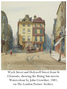
This watercolour by John Crowther shows us looking from where we are standing now in 1881. Wych Street veers to the right, and Holywell Street runs through what is Australia House. The Strand is just out of the frame, the next road to the left.
Despite the jolly colours in the painting, once between the buildings, things were not so bright. Also, notice how there are no trees lining the streets.
In his Old and New London: Volume 3, 1878, journalist Walter Thornbury describes:
“the narrow, dark, and irregular alleys in the neighbourhood of Clare Market and Wych Street [were] encumbered with low projecting eaves, arched doorways, and bulkheads.
Thornbury explains that Wych Street, winding to the right in the painting:
“contains, especially on the south side, some of those curious old wooden-fronted and gabled houses which are equally picturesque and inconvenient. Like Holywell Street, of late years this thoroughfare has gained a notoriety for the sale of books and prints of an immoral class, and at present the sale of them is only partially suppressed."
Thorbury's euphemistic 'books and prints of an immoral class' refers to the thiriving pornographic trade in the area.
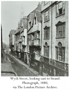
This photograph from 1880 gives more of an idea of the over-hanging gabled houses that Thorbury refers to.
All around the Aldwych area, the streets were like this. To the north east, where LSE is now, was the Clare Market area. This was notorious for its winding streets.
Thornbury recounts a story that gives an idea of how dangerous and difficult some Londoners thought the area was:
“there is a legend hereabout that years ago a young man from the country, bearing a black bag, started one winter night from Portugal Street to get into the Strand, and that he has been wandering round and about ever since, constantly returning with a disconsolate aspect to his original starting-point. On foggy nights his form may be descried in Clare Market. Anyhow, no one has yet heard that he ever reached the Strand."
Gardens for the rich
On the City of London and Metropolitan Archives website, you can find many different views of the old streets. Perhaps the artists weren’t focussing on the greenery of the area and wanted to exaggerate how built up it was, but there are few images that even include a solitary tree.
But, as we saw on Booth's Poverty Map, richer and poorer inhabitants lived alongside each other, not so different to today.
There were gardens and greenery, if you knew the right people. One of these places was the garden at New Inn. You can see it on the Booth map, it’s just underneath the ‘CLEM’ of the printed 'St Clement Danes'.
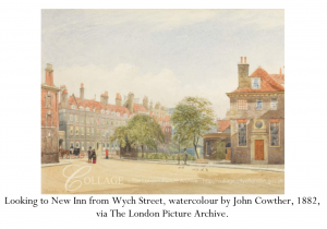
Just behind Clare Market, this Inn of Court had beautiful shaded grounds, which we can glimpse in this painting by John Crowther.
Thornbury describes this as a pleasant garden and park that you might walk through, although it is gated and locked at sundown, and filled with law students.
Clearing St Clement Danes
The London Council’s medical officer first flagged the Clare Market area for development on 19th September 1892. Outbreaks of disease were difficult to control, and few houses had running water.
Over 3,000 people would be displaced from the Clare Market area alone. The area was incredibly dense, with 800 people to the acre (1 acre is smaller than the size of a football field).
From Wych street, Newcastle street, and the smaller roads on what is now the west end of Aldwych, 3000 further people had to be re-housed. 1,500 people were re-housed on the Millbank Estate in Pimlico in Westminster, with only 750 re-housed around the rebuilt Clare Market area.
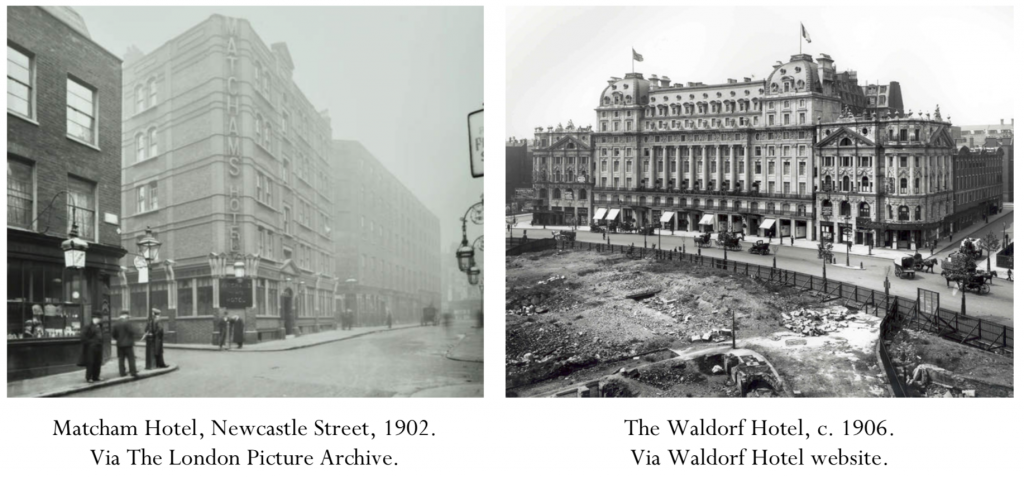
The Council negotiated to buy land to create more housing around Covent Garden from Hastings William Sackville Russell, 12th Duke of Bedford (1888–1953). As part of the bargain, the Duke got a good price on the land at the north-west of Aldwych on which the Waldorf complex was built, ensuring himself a tidy, ongoing profit! The photographs above show the change in style, from the rather modest Matcham Hotel, to the grand Waldorf.
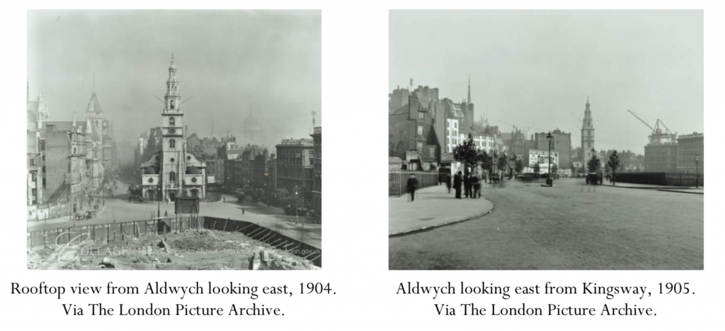
Work eventually began on what we now know as Aldwych and Kingsway in 1902. The idea was to create a Parisian-style boulevard. The French Emperor Napoléon III had directed Georges-Eugène Haussmann to redesign the French capital between 1853 and 1870, and the British were keen to produce their own suitably Imperial cityscape.
The wide roads - lined by trees - and monumental buildings represented the ideal of empire. These developments happened at the same time as improvements to Buckingham Palace and Trafalgar Square as part of a plan to create a great processional route to St Paul’s. You can see the tiny Plane trees in the bottom right photograph - the first green on Aldwych for centuries!
Directions to Stop 3: Unexpected blooms
Turn around and face St Clement Danes. Walk to the right of the Church, along the narrow footway. Along the side of the church, be careful where you tread, and keep your eyes peeled for little shoots of greenery!
